signed access forms
As of August 31, 2026Founding edition · 2026
Places & research
Radiological places
Find a place, read its story, and follow the evidence. This collection includes industrial history, completed cleanups and unresolved investigations. Inclusion does not mean a place presents a current radiation risk.
27 of 27 records
A
Ashland 1 / Former Ashland Oil RefineryTown of Tonawanda · Erie County
Former River Road refinery property where Linde uranium-processing residues had been stored before Ashland Oil acquired the land; federal cleanup was completed in 2003.
Ashland 2 FUSRAP SiteTown of Tonawanda · Erie CountyFormer industrial landfill that received radioactive soil excavated from Ashland 1 in 1974; federal cleanup removed more than 52,000 tons of material.
B
Bethlehem SteelLackawanna · Erie County
Former integrated steel complex where Seneca Steel began production in 1902 and Bethlehem Steel operated from 1922. About 440 acres of the present property are manmade land built with slag and manufacturing waste. Cleanup, monitoring, groundwater treatment, habitat work, and land-use controls continue across separately managed portions of the site.
Black Creek Village / 99th Street Fill InvestigationNiagara Falls · Niagara CountyResidential industrial-fill investigation near 99th Street, alongside a separate history of pesticide-affected fill removal at Black Creek Drive. The neighborhood marker is approximate.
Bliss & Laughlin SteelBuffalo · Erie CountySteel facility where uranium rods were machined and straightened in 1952 for an Atomic Energy Commission contractor; the affected area was remediated under FUSRAP.
C
Carborundum — Buffalo Avenue Building 1Niagara Falls · Focused research
The documented 1959–1967 nuclear-fuel program and the distinction from the separate Globar property.
CECOS International Waste FacilityTown of Niagara / Niagara Falls · Niagara CountyLarge waste-management property used for disposal since 1897 and for hazardous-waste treatment, storage, and disposal beginning in 1977. Investigations found releases to fill, soil, and groundwater from historic waste-management units. Closed units are capped and maintained, contaminated groundwater is recovered and treated, and long-term monitoring and corrective-action controls continue under state and federal hazardous-waste permits.
D
E
EAD Metallurgy Americium-241 OperationTown of Tonawanda · Erie County
Former smoke-detector-foil operation at 71 Pearce Avenue. Public records document releases of americium-241 to the sanitary sewer, accumulation in treatment sludge, incineration, and disposal at the Town of Tonawanda landfill. This sewer-and-sludge pathway is separate from the Linde uranium-residue history.
Electro Metallurgical CompanyNiagara Falls · Niagara CountyUnion Carbide subsidiary that converted Linde uranium tetrafluoride into uranium metal, producing more than one-third of the Manhattan Project’s uranium-metal requirement.
F
G
H
L
N
Niagara Falls Boulevard Radiation SiteNiagara Falls · Niagara County
Radioactive slag fill was removed from parking lots and interior areas at the documented 9512–9626 Niagara Falls Boulevard properties.
Niagara Falls Storage SiteLewiston · Niagara CountyFederal site within the former Lake Ontario Ordnance Works where a 10-acre engineered structure still holds radioactive residues, contaminated soil, and demolition debris. Complete removal and out-of-state disposal were selected, but removal is not complete.
Niagara Falls Storage Site Vicinity PropertiesLewiston and Porter · Niagara CountyProperties surrounding the federal storage site that have been investigated or remediated individually for material associated with the Niagara Falls Storage Site.
Niagara–Erie Residential Radiological AssessmentTown of Niagara · Niagara CountyOngoing three-phase regional assessment using aerial, roadway, and property-level surveys. Agencies are screening hundreds of locations, conducting soil and laboratory follow-up where warranted, and offering temporary relocation to some households. Contact or screening does not mean a property is confirmed contaminated.
P
S
Seaway FUSRAP Site / Tonawanda North Unit 3Town of Tonawanda · Erie County
River Road landfill areas containing material moved from the former Ashland property, where residues from Linde uranium processing had been stored.
Southtowns / Buffalo SlagErie County · Focused researchAbbott Road, Republic Steel and the historical construction-material chain. A delivery route for current radiological findings remains unproven.
T
Titanium Alloys Manufacturing / TAM CeramicsTown of Niagara · Niagara County
Manufacturing property at 4511 Hyde Park Boulevard where federal records document a 1955 experimental melt of uranium-contaminated stainless steel and aluminum. The survey table identifies “Slag from Melt,” but the reviewed public record does not establish where that experimental slag was ultimately placed. A separate two-day uranium-compound experiment followed in 1956. Later state cleanup records address the broader industrial property and adjoining landfill corridor.
Tonawanda Landfill FUSRAP Vicinity PropertyTown of Tonawanda · Erie CountyTown landfill and mudflats vicinity property where radioactive material resembled material at other FUSRAP sites, although no record ties the property to Manhattan Engineer District or Atomic Energy Commission operations.
U
V
W
West Valley Demonstration ProjectAshford · Cattaraugus County
Federal cleanup and decommissioning project at the former commercial nuclear fuel reprocessing facility.
Witmer Road Drive-InTown of Niagara · Niagara CountyFormer theater at 4287 Witmer Road with documented industrial fill and environmental investigations. DEC site 932118 is separate from the James Avenue/Witmer Road Disposal Site (932027).
Full investigation, interactive map & source archive
Niagara–Erie radiological investigation
EPA, NYSDEC, and NYSDOH are investigating radiological material across roughly 1,000 square miles in Niagara and Erie counties. Teams are following aerial and roadway screening with ground surveys and property testing. A screening signal does not mean contamination is confirmed.
Open the interactive mapproperties screened
As of August 31, 2026properties notified no additional radiological investigation was needed
As of August 31, 2026parcels referred to EPA
As of August 31, 2026properties recommended for voluntary temporary relocation
As of August 31, 2026Property-level progress reported August 31, 2026. These counts describe different stages and should not be added together. Referral or a relocation recommendation does not by itself establish a final contamination classification or identify the source material. DEC-submitted update ↗
How to read this page →How to read this page and map
Start with the dated figures, then choose a marker to read its finding and source. Historical readings describe conditions at the time; they do not establish present-day exposure.
This is ongoing—not a completed historical survey
See what is known and still open →The map combines the active regional assessment with the older evidence investigators are using to understand it. A screening signal is not the same as a confirmed contaminated property, but confirmed elevated residential findings and temporary relocations mean this work cannot be presented as history alone. Every marker states whether it represents an old reading, completed removal, active review, or unresolved lead.
Current investigation · dated public findings
Aircraft found the pattern; field teams are now working property by property.
An area of interest is a screening result—not a contaminated property. Each stage narrows the question, and not every location advances to the next step.
July 20, 2026 investigation baseline: roughly 1,000 square miles screened, more than 500,000 aerial data points evaluated, approximately 380 areas of interest, and about 160 areas advancing to ground surveys. Areas of interest and individual properties are different measures; these baseline figures should not be added to the August property counts.
September 10, 2026 — Federal oversight. Congressman Tim Kennedy requested written answers from EPA and USACE about material origins, sampling and laboratory analysis, testing timelines, risk assessments, resident protections, relocation assistance, and property values. The request does not establish the source of the material. Official release ↗
Federal reference: EPA identifies the assessment as NY8180000160, a Removal Only Site that is not on the National Priorities List. This program record does not classify every screened property as contaminated. EPA site record ↗
What the public record establishes
- Radioactive industrial material was historically produced, handled, stored, and reused as fill in the region.
- The 1986 report separated 38 NFSS-related locations from 62 other anomalies.
- EPA later completed documented removals at several Niagara County properties.
- The current three-phase state and federal assessment remains active.
- DEC separately confirms an active investigation of industrial fill uncovered at a 99th Street property in Black Creek Village.
What is not yet publicly resolved
- The total number of properties with material that presents a current risk.
- How many modern signals reflect natural geology versus man-made material.
- Which current areas precisely overlap the 100 numbered 1984 survey locations.
- The eventual number of cleanups or no-further-action decisions.
- The chemical composition and source of the newly investigated Black Creek Village fill.
How the investigation works
These steps show how a screening signal can lead to an agency decision. Not every location needs every step.
Explore the 9-step investigation process
- 01Aerial survey2023–2024 regional screening
- 02Roadway survey2025 targeted corridors
- 03Area of interestopen the comparison map
- 04Ground surveysee mapped public findings
- 05Property accessread the agency records
- 06Detailed samplingreview supporting documents
- 07Laboratory analysisreview technical evidence
- 08Risk assessmentread agency interpretations
- 09Agency decisioncompare documented outcomes
Connected investigations
Connected place records and investigations
The active assessment provides the regional frame. These focused records preserve separate places, material chains, witnesses, and evidentiary limits.
Witmer Road Drive-In
Industrial fill and a documented 2020 radiation survey.
Read the environmental record →Southtowns / Buffalo Slag
Abbott Road, Republic Steel TENORM, and the documented construction-material chain.
Read the full record →Black Creek Village
The 99th Street chemical-fill investigation and earlier removal history.
Read the full record →1979 Pine Bowl dossier
The full witness-by-witness Probe Services record, with corroboration and explicit limits.
Read the full record →1986 DOE/ORNL survey
The 100-point historical reference dataset remains paired with the interactive map and downloads.
Explore the survey →Desktop: click a marker; drag to pan and use +/− to zoom. Mobile: tap a marker; use two fingers to move the map. The full record appears below on smaller screens.
What the map layers mean
Click or tap any marker for a quick identification. Its complete sourced record opens beside the map on desktop and directly below it on mobile. Marker color separates NFSS-related locations from the other DOE/ORNL anomalies. Blue squares mark official Level B waste-history records; yellow dashed circles mark unconfirmed Level C testimony. The 2025 roadway work is shown as survey coverage because agencies have not released property-level findings as public pins; teal pins represent newer sites with an official EPA location and outcome. Use the aerial selector to place the same pins over georeferenced government imagery.
1986 map · reported remediated 1986 map · other anomaly Approximate/unresolved Newer documented site Production, processing, or storage Level B · official waste-history record 1979 testimony lead · approximate Erie County Niagara County 2025–26 survey coverage
1984 U.S. Department of Energy / Oak Ridge National Laboratory survey
1984 anomaly 1
2,200 feet east of Creek Road along Pletcher Road · Pletcher Road
NFSS-related; report states remediation occurredMap position: survey offset approximate
What the historical record says
The DOE/ORNL report attributed this Pletcher Road anomaly to Niagara Falls Storage Site-related material. It was among the 38 locations later remediated under FUSRAP.
Latest public comparison · July 2026
The historical remediation and federal certification records remain the latest location-specific public outcome linked to this numbered point. The current NECRA materials do not publish a newer result matched to this exact pin.
Recorded in 1984
- At surface
- 31 µR/h
- Scan range
- 11–86 µR/h
Historical instrument readings are reproduced for context. They do not establish present-day exposure or conditions.
Source
DOE/ORNL Niagara Falls radiological measurements report (1986) ↗Background and full evidence
Explore the historical records, technical findings, and limits behind the map.
Investigation background
EPA, NYSDEC, and NYSDOH are conducting a large, active search for radiological material across Niagara and Erie counties. The work covers roughly 1,000 square miles, builds on more than 500,000 modern aerial data points, and has moved from aircraft and roadway screening into neighborhood surveys, residential testing, laboratory analysis, temporary relocations, and cleanup planning. The historical slag and uranium records below explain why investigators are finding a regional problem rather than one isolated site.
Old industrial slag is a testable lead—not a proven explanation for Southtown radiological signals.
Southtowns slag investigation · newest to oldest
Old industrial slag is a testable lead—not a proven explanation for Southtown radiological signals.
Government records now connect Buffalo-area iron and steel slag to TENORM, a historical processor, construction markets, and surviving Southtown infrastructure. They do not yet connect those facts into one proven radiological delivery route.
The investigation question
Are current Southtown radiological areas of interest occurring where historical industrial slag was placed? Public property-level survey coordinates, laboratory results, construction records, and delivery records are needed to test that question.
- Proven
Abbott Road contains documented slag; its radiological character remains untested publicly.
Erie County's December 2025 assessment says record plans, 1990 bridge borings, and March 2025 project borings indicate slag beneath Abbott Road and around the Smoke Creek bridge abutments. The consultant recommended radiological screening and laboratory analysis if field readings are elevated. The report identifies TENORM as a potential concern; it does not report that the Abbott Road slag is TENORM.
Read the Erie County assessment, PDF pages 56–58 ↗ - Proven
Former Republic Steel slag was identified as low-level Ra-226 TENORM.
A March 2015 load excavated during RiverBend redevelopment triggered a recycling facility's radiation monitors and was returned to the site. The later DEC-filed work plan identifies subsurface iron- and steelmaking slag as the source of low-level TENORM and radium-226 as the principal isotope. This establishes radiological slag at the former Republic property—not the radiological character of every Republic load.
Read the RiverBend TENORM work plan ↗ - Reason unresolved
Hamburg Engineering instructed a developer to specify “NO SLAG.”
The Town Engineering Department's Lincoln Square Apartments review required “NO SLAG” in every detail and stone within the Town right-of-way. The document proves the instruction existed by March 8, 1989. It gives no reason, and WNY Atlas has found no evidence that the restriction was adopted because of radiation rather than engineering performance or another concern.
Read the Hamburg Planning Board file, PDF page 14 ↗ - Proven
Republic and Hanna Furnace slag entered Buffalo Slag's construction-material stream.
A NYSDOT-commissioned site characterization says Buffalo Slag operated the Steelawanna property from about 1913 to 1983. It identifies Hanna Furnace “hard” slag and Republic Steel lightweight slag, mixed, crushed, screened, and sold for road base and embankment fill. A separate Hanna Furnace report says Buffalo Slag bought and removed Hanna slag, recovered iron, and sold the remainder for road bases or railroad ballast.
- Proven
Buffalo Slag offered Woodlawn-produced aggregate to the Town of Boston.
The municipal bid file lists crushed blast-furnace slag grades and crusher-run products available from Buffalo Slag's Woodlawn Plant No. 81 in Hamburg, with delivered prices and a representation that the aggregates met state transportation specifications. This documents a Southtown construction market; it does not identify a radiologically elevated batch or a particular placement location.
Read the Town of Boston bid file, PDF pages 97–100 ↗ - Statewide mechanism
DEC confirms the broader historical pathway beneath roads and construction projects.
DEC's TENORM policy history explains that slag and other TENORM-containing ore-refining byproducts were historically used as inexpensive construction backfill without consideration of their radioactivity. The statewide policy validates the mechanism, but it does not identify Buffalo Slag, Abbott Road, or any Southtown property as radiologically contaminated.
Read NYSDEC's TENORM policy notice ↗
Documented chain
- Republic Steel and Hanna Furnace slag reached Buffalo Slag's processing stream.
- Buffalo Slag sold processed material for road base, embankment fill, ballast, and Southtown aggregate markets.
- Slag remaining at former Republic Steel was later identified as Ra-226 TENORM.
- Historical slag remains beneath Abbott Road and near the Smoke Creek bridge abutments.
Unresolved bridge
- Whether TENORM-bearing Republic slag entered Buffalo Slag's construction products.
- Whether Abbott Road slag or another Southtown placement contains TENORM.
- Whether current radiological areas of interest overlap documented slag placements.
- Why Hamburg prohibited slag in Town right-of-way details by 1989.
Niagara's documented phosphate-slag and federal radiological-material distribution history remains a separate evidence branch. WNY Atlas does not use it to infer that Niagara material traveled south or that Buffalo-area iron and steel slag had the same origin or isotope profile.
Black Creek Village: chemical-fill investigation
A separate environmental investigation at 99th Street
The July 31, 2026 report quotes DEC saying the property’s surface radiation scan found no readings above background. Chemical sampling and the historical fill-removal record remain separate questions.
Read the Black Creek Village environmental record →What the 1986 DOE/ORNL report concluded
One survey, two different historical findings
38 NFSS-related locations
DOE/ORNL attributed these locations to material connected with the Niagara Falls Storage Site. The report states that material exceeding the applicable FUSRAP guidelines was removed and the locations were remediated.
62 other survey anomalies
The report generally associated these readings with phosphate furnace slag used beneath asphalt, in driveways, or as gravel. They were not attributed to NFSS, but that does not mean the slag had no radioactivity.
These are historical classifications. The 1986 report does not establish present-day conditions at an individual property, and a mapped survey point does not by itself prove which material remains there today.
The 1979 interviews expand the research network, but they do not prove one source for every hotspot.
Slag sources and distribution · evidence kept separate
The 1979 interviews expand the research network, but they do not prove one source for every hotspot.
What the 1979 reports add
A private investigator recorded interviews describing Friona hauling, a Union Carbide dump near 56th and Pine streets, a Vanadium-area stockpile account, and reported slag use at former retail properties. These are useful contemporaneous leads, so the map shows them as yellow dashed markers. They are not agency sampling results or present-day hazard findings.
56th/Pine now has two evidence levels
An official remedial-investigation history documents Union Carbide furnace slag, hydrated lime, and miscellaneous plant-waste disposal at a 56th Street and Pine Avenue facility. That supports a Level B marker. John Friona's separate account of a fenced radioactive-slag burial remains Level C because no reviewed agency record locates or confirms that burial cell.
The source-attribution correction
A 2020 appellate decision summarizes a 2008 fingerprinting study that found slag from the Union Carbide predecessor facility markedly different from material recovered at the Niagara Falls Boulevard and Holy Trinity sites. The historical distribution account therefore cannot be used as proof that Union Carbide supplied every radioactive slag location. The underlying laboratory file has not been recovered from a public repository, so this page reports the court's conclusion without adding unreviewed analytical detail.
Newer site-specific evidence and a full Sabre Park story
A 2017 assessment for 4435–4445 Military Road estimated about 500 tons of slightly elevated radiological fill. The record also preserves a prior non-confirmation by EPA and does not establish where that fill originated. It appears as a documented assessment pin, not a completed cleanup or source assignment. The 2014 Fashion Outlets / Sabre Park encounter now links to a full main-map story that keeps its 1978 fill, 1989 mercury removal, 1994-95 waste response, and radiological work separate.
Read the 1979 investigator reports ↗Read the 2020 source-fingerprint decision ↗Read the official 56th/Pine disposal history ↗Read the Military Road assessment ↗Open the full Sabre Park site story →
Evidence levels used here: A = agency sampling, removal, or laboratory record; B = official industrial or waste-history record; C = named contemporaneous testimony. No route line is drawn unless a reviewed record identifies the relationship directly.
Inside the 1979 Pine Bowl investigation
Original record dossier · all 12 scanned pages reviewed
Inside the 1979 Pine Bowl investigation
Probe International Investigators Ltd. prepared reports dated May 10 and June 8, 1979 for George Gellman of Consolidated Bowling Corporation. Evan P. Kenner authored the reports; Lewis Barone conducted many of the Niagara Falls interviews. The June supplement includes Kenner's June 4 interview with John Friona.
Kenner records meeting with the Pine Bowl owner and defining the question of who supplied or placed slag beneath the property.
Barone's contractor and supplier interviews identify possible sources, haulers, competing construction accounts, and named fill destinations.
Kenner records Friona's account of the Hackett/Friona arrangement, the 56th/Pine dump, and separately managed radioactive slag.
The second report adds the Friona interview, Vanadium/Pittsburgh Metallurgical leads, and unresolved people or records to pursue.
How to read these accounts Corroborated context Testimony only Qualifying or competing account
May 10, 1979LaVay MelnotFriona hauling and the Union Carbide dump
What the report records
The report records Melnot saying Philip and Nazarino Friona operated a trucking company whose early-1960s work included hauling waste and slag from Union Carbide grounds to the Union Carbide dump, later Newco.
Independent check and limit
Government records support the old Union Carbide dump/Newco geography, but WNY Atlas has not found a hauling contract or load record confirming Melnot's account.
May 10, 1979Armand CerroneRegional slag sources and contractor access
What the report records
The report records Cerrone identifying Union Carbide, Airco Alloy, and Buffalo Slag as major 1962 sources and saying contractors obtained Union Carbide slag through Friona, by pickup or delivery.
Independent check and limit
The named industrial operations are documented, and other 1979 interviews describe the same Friona relationship. No reviewed invoice or exclusive-rights agreement confirms the commercial arrangement.
May 10, 1979Vince FarinaTwin Fair and Michael's Pizzeria
What the report records
The report records Farina naming the former Twin Fair parking area and Michael's Pizzeria as places where Union Carbide slag was reportedly used. He also described high-lime material lifting or damaging blacktop.
Independent check and limit
Historical geography supports both named places. WNY Atlas has not found radiological sampling that confirms the material, source, quantity, or present conditions at either destination.
May 10, 1979Angelo MarchettiKing's Plaza and wider parking-lot use
What the report records
The report records Marchetti describing broad use of Union Carbide slag beneath Niagara Falls parking lots and identifying the former King's Plaza on Military Road as one example.
Independent check and limit
The exact former plaza parcel has not been independently resolved, so the account remains searchable but intentionally has no map pin.
May 10, 1979John and Joseph SeprelliWho placed the original Pine Bowl fill
What the report records
The report records the Seprelli account that low spots had already been filled with slag before their stone, gravel, and blacktop work and that they did not believe their company supplied the original slag.
Independent check and limit
This is a material qualifying account: the report does not resolve who placed the original slag and cannot support assigning Pine Bowl solely to Seprelli.
June 8, 1979John FrionaC.A. Hackett, Friona, and Union Carbide
What the report records
Kenner records his June 4 interview with Friona, who described a C.A. Hackett/Friona arrangement involving Union Carbide slag beginning around 1955-56 and identified the 56th/Pine dump as the later Newco property.
Independent check and limit
Federal and state records support Union Carbide industrial-waste disposal and possible Electromet rubble at the old dump. The specific Hackett/Friona arrangement remains testimony without a reviewed corporate record.
June 8, 1979John FrionaReportedly segregated radioactive slag
What the report records
The report records Friona recalling radioactive slag isolated roughly a quarter-mile from other slag, buried, and fenced or cabled. He believed Bruno Scrufari excavated the burial area.
Independent check and limit
A federal record separately documents 505 tons of thorium- and uranium-bearing commercial slag buried on Electromet plant property from 1965-72. It does not establish that this was the same burial area Friona described at the dump.
June 8, 1979Clarence FrangionePittsburgh Metallurgical and Vanadium slag
What the report records
The report records Frangione describing slag associated with Pittsburgh Metallurgical and lime slag from the old Vanadium plant, along with a recollection of radioactive-material stockpiles at a Lockport Road dump.
Independent check and limit
Government records confirm the large Vanadium/Airco slag-production and disposal history. The radioactive-stockpile portion remains unconfirmed testimony.
June 8, 1979Joseph JohnsonOther possible sources and haulers
What the report records
The report records Johnson identifying Union Carbide, Airco Alloy, and Oldbury as slag sources and directing investigators toward Walter Kozdranski as a possible hauler.
Independent check and limit
The industrial sources and Kozdranski business identity can be independently placed in the period, but WNY Atlas has not found records connecting Kozdranski to a specific load or radiological destination.
Names and records still requiring archival proof
C.A. Hackett job or corporate files; Harold Heinrich's employment role; Bruno Scrufari excavation records; Walter Kozdranski hauling records; Friona invoices or dispatch books; the former King's Plaza parcel; and the underlying 2008 slag-fingerprinting laboratory file. These remain research targets, not affirmative map claims.
What later records add—and what they still do not prove
Additional primary-record research
What later records add—and what they still do not prove
Commercial radioactive slag is documented
A federal Electromet record says Union Carbide produced 505 tons of commercial slag from 1965 to 1972 containing 9,212 pounds of thorium dioxide and 1,293 pounds of uranium oxide, drummed and buried in a designated area on plant property.
DOE Former Electromet elimination report ↗The old dump connection is plausible but bounded
The same federal record says some demolished-plant rubble may have reached the 200-300 acre old Union Carbide dump north of Pine Avenue, later Newco/CECOS.
DOE Former Electromet elimination report ↗A later commercial-fill encounter is confirmed
During 2014 Fashion Outlets/Sabre Park construction, a work-plan appendix documented slag about one to three feet below grade, readings of 35,000-52,000 counts per minute in the excavation, and 65,000 at a returned truckload against 5,000-7,000 background.
NYSDEC file: Fashion Outlets/Sabre Park final engineering report, Appendix F ↗The single-source theory does not hold
The 2020 court record summarizes fingerprinting that found Union Carbide predecessor slag markedly different from material recovered at Niagara Falls Boulevard and Holy Trinity.
New York appellate decision ↗Survey coverage, then and now
Aerial and roadway evidence
What agencies surveyed, then and now
These official figures show where agencies looked. Their outlines and route lines describe survey coverage—not confirmed contamination, property boundaries, or exposure areas.
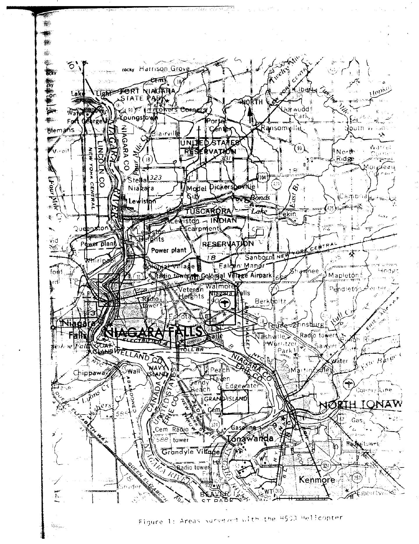
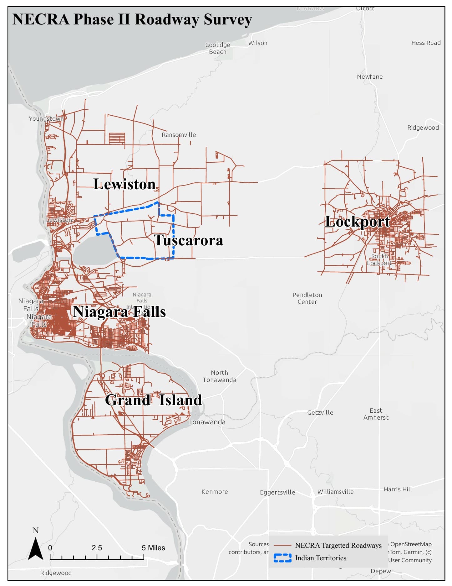
Documented atomic-energy work · reviewed September 28, 2026
Bethlehem Steel: uranium rolling at the 10-inch mill, 1949–1952
Bethlehem's Lackawanna works participated in the AEC uranium program during 1949–1952. Its 10-inch continuous bar mill rolled uranium for reactor fuel supporting plutonium production. Experimental and production runs also informed the rolling process at Fernald, Ohio. Uranium work generally occupied weekends between ordinary steel shifts. This was an occupational radiation history within the larger steel complex.
Heating trials used lead and molten-salt baths; salt reduced oxidation and airborne dust. NIOSH's technical basis describes possible resuspension of uranium oxide mixed with steel dust on subsequent steel-production days, for which it found no air or surface surveys. Read the technical basis, sections 2 and 3.6 ↗
A documented material route to LOOW
NIOSH's 2013 review identifies three barrels at Lake Ontario Ordnance Works containing more than 600 pounds of Bethlehem uranium dust and oxides. It also cites transfers of rods and scrap. These are recorded movements into federal storage, not a reconstruction from geographic proximity. Read the LOOW/Niagara Falls Storage Site history. Shipment references: Attachment 2 ↗
Workers, cleanup and the later federal findings
SC&A's 2004 review preserves worker accounts of dust remaining for weekday shifts, scale washed into pits, pit cleaning and salt-bath work. It also records allegations of uranium-bearing material entering furnaces. These accounts identify specific work practices and records to investigate; they do not independently verify material destinations or uranium in finished steel. Read the attributed accounts and review questions ↗
NIOSH's 2013 conclusion affirms internal and external worker exposure during uranium operations. It also concludes that cleanup was effective and significant residual radioactive contamination was not present after AEC work ended in 1952. The review considered operating records, surveys, models and worker affidavits. That conclusion is part of the record alongside the testimony. Read the 2013 conclusion ↗
DOE's later surveys of former process areas and remaining equipment found no significant residual radioactivity and led to elimination from FUSRAP consideration. This site decision addresses residual conditions; it does not negate radiation exposures during production. Read the elimination report and survey scope ↗
A qualifying class of employees working January 1, 1949–December 31, 1952 entered the Special Exposure Cohort effective August 13, 2010. The class requires at least 250 qualifying workdays, including permitted combinations with other SEC employment. Compensation eligibility has additional requirements; the designation is not a count of illnesses or a finding of current site contamination. Read the official class definition ↗
Smokes Creek and shoreline fill: the remaining questions
The Smokes Creek record documents steelworks discharges and sediment cleanup. The reviewed uranium records do not verify a uranium route to the creek, Lake Erie, residential fill or a specific slag deposit. The creek sediment project should not be described as a uranium cleanup. Nor do the LOOW shipment records place those particular barrels in today's containment structure.
Next records: locate the 10-inch mill against surveyed plans; trace its drains, scale pits and outfalls; recover the cited shipment and scrap ledgers; identify spent-bath disposal records; and compare later sampling locations with those process areas. Modern slag radiological results would need both location and material identification before linking them to this program. A plant-wide map marker does not locate the mill or a release.
Technical industry records
Newly verified industry records
Three documented operations - and three boundaries the evidence does not cross.
These records describe industrial work and explain which material destinations remain unknown.
TAM: documented melt, unknown destination
Confirmed: NIOSH records a 1955 AEC pilot melt at Titanium Alloys Manufacturing using 40 pounds of uranium-contaminated stainless steel and 30 pounds of aluminum shipped from Mallinckrodt - about 90 grams of uranium in total. Input material reached 26,800 dpm/100 cm², and the survey table identifies slag from the melt. Separate bench-scale uranium-compound work followed July 10-11, 1956.
Research boundary:the reviewed public record does not say where the experimental slag ultimately went. TAM's nonradioactive zirconium-operation shipments to LOOW do not answer that question and are not used here to connect the melt to a later fill site.
Read NIOSH SEC-00190 ↗Tonawanda Am-241: a separate sewer pathway
Confirmed:New York State Archives describes EAD Metallurgy's approximately 1977-1983 production of Am-241 foil elements for smoke detectors and releases to the sanitary sewer that contaminated sewer lines, the sewage-treatment plant, and landfill. A federal administrative record traces the material from sewer to treatment sludge, through the municipal sludge incinerator, and into the eastern landfill.
Pathway boundary: this later americium history is not the Linde uranium story and is not part of the Niagara County solid-slag distribution record.
Open New York State Archives series 20691 ↗Read the federal landfill pathway record ↗Carborundum Buffalo Avenue: Building 1 nuclear-fuel research
Read the Buffalo Avenue research page →
Confirmed: NIOSH documents experimental centerless grinding of ten uranium slugs, totaling approximately 30 pounds, from June through September 1943, at an unresolved location. NIOSH places the separate 1959–1967 AEC fuel-development program involving uranium and mixed uranium/plutonium carbide and related fuel materials in Buffalo Avenue Building 1, not the separately mapped Globar property.
The June 2026 overview places the plutonium facility in the fourth-floor Central Laboratory. It lists broader Building 1 work dates of 1957–1968 separately from the covered 1959–1967 operational period. Neither date range establishes a waste-disposal route.
Research boundary: the work-site record strengthens the industrial history but does not prove that Carborundum supplied the material at any particular off-site slag or fill location.
Read the NIOSH Carborundum site profile ↗Read the June 2026 location clarification, slides 8–12 ↗
Globar’s separate solvent-cleanup record →
Open records: Building 1’s surveyed location, demolition and radiological-release documentation, shipment manifests, and landfill acceptance records identifying material and source building. Company-level landfill references do not establish disposal of radioactive material from this laboratory. No precise Building 1 pin is assigned pending location verification.
Linde material pathways
One plant, distinct material routes
Linde's solid residues and liquid effluent did not follow one path.
Federal records describe several routes from Linde's Manhattan Project-era uranium processing. They belong in one history, but they are not interchangeable evidence and should not be drawn as one continuous shipment chain.
Solid residues and fill
Solid uranium-processing residues were stored or moved among the Linde, Ashland, Seaway and Tonawanda Landfill FUSRAP records. Each destination retains its own chain-of-custody and cleanup findings.
Sanitary-sewer discharge
Linde liquid process wastes were initially discharged to town sewers. This is a liquid-effluent route, not proof that the same solid residues entered the sewer or treatment sludge.
On-site disposal wells
EPA's 1982 overview reports that about 37 million gallons of wastewater containing radioactive materials were injected into five approximately 150-foot-deep wells at Linde.
Storm drainage to Two Mile Creek
When wells plugged or overflowed, federal records say effluent could be diverted through a former storm-drainage ditch to Two Mile Creek. A 1981 survey generally found sampled creek media comparable to baseline locations; that result does not erase the documented historical route.
EAD Metallurgy's later Am-241 sewer-to-sludge-to-incinerator-to-landfill route is another distinct Tonawanda history; it is not a continuation of Linde's uranium-processing pathway.
Read the 1981 Linde liquid-pathway survey ↗ · Read EPA's 1982 Niagara Frontier overview ↗
Government record and research archive
Read the evidence behind the map
This library includes every government survey, audit, certification, cleanup record, and technical worker review currently relied upon by this investigation. Draft or ongoing work is labeled as such.
44 of 44 reviewed government records shown
Carborundum site overview and location clarification
June 16, 2026 · Worker-exposure record
What this record establishes
Places the second operational period in Buffalo Avenue Building 1; explicitly leaves the 1943 grinding location unknown.
Map connection: Corrects the former Globar attribution. Building-level coordinates and waste routes remain unresolved.
Bethlehem Steel residual-contamination review
May 23, 2013 · Worker-exposure record
What this record establishes
Documents occupational exposure, cleanup evaluation and Bethlehem residue transfers to LOOW; concludes significant residual contamination was not present after the 1952 end of operations.
Map connection: Plant marker only; neither a current radiological finding nor a verified creek or slag-disposal route.
SEC Petition Evaluation Report SEC-00190 - Titanium Alloys Manufacturing
February 14, 2012 · Worker-exposure record
What this record establishes
Documents the 1955 pilot remelt of 40 pounds of uranium-contaminated stainless steel and 30 pounds of aluminum from Mallinckrodt, approximately 90 grams of uranium in total, a maximum input-material surface reading of 26,800 dpm/100 cm², slag produced by the melt, and separate July 10-11, 1956 bench-scale uranium-compound work. NIOSH found dose reconstruction feasible for the evaluated 1955-1956 class and proposed no SEC addition.
Map connection: Confirms a small, time-bounded radiological operation at TAM. It does not document the experimental slag's ultimate destination or connect TAM to a particular residential fill site.
Site Profile for The Carborundum Company
April 23, 2020 · Worker-exposure record
What this record establishes
Documents experimental grinding of ten uranium slugs in 1943 and a separate AEC fuel-development program from 1959 through 1967 involving uranium and uranium/plutonium materials.
Map connection: Strengthens the Carborundum facility history while leaving any claimed off-site waste or fill destination unproven unless a shipment, disposal, or analytical record is found.
Radioactive Waste Site Records - EAD Metallurgy cleanup files
Records dated 1982-1995 · Cleanup and administrative record
What this record establishes
The official finding aid records that EAD manufactured Am-241 smoke-detector foil elements circa 1977-1983 and released Am-241 to the Town of Tonawanda sanitary sewer, contaminating sewer lines, the sewage-treatment plant, and landfill. The state certified the property for future use in 1995 under applicable radiological guidelines.
Map connection: Adds a separate Tonawanda liquid/sewer and municipal-waste pathway. It must not be conflated with the older Linde/FUSRAP uranium network.
Cleanup of Americium-241 Contamination at EAD Metallurgical and the Town of Tonawanda Sewer System
January 19, 1987 · Cleanup and administrative record
What this record establishes
Records EAD's Am-241 smoke-detector foil operation, unsuccessful initial building decontamination attempts, and the discovery of Am-241 in the sanitary sewer leading from the facility.
Map connection: Primary administrative-history support for the EAD building and sewer pathway; it is separate from the Linde/FUSRAP uranium source history.
Tonawanda Landfill Radiological Investigation Work Plan
September 1994 · Audit, certification, or technical review
What this record establishes
Explains that Am-241 released by EAD entered the sanitary sewer, concentrated in sewage-treatment sludge, passed through the municipal sludge incinerator, and was deposited in the eastern landfill. It reports 1988 characterization finding Am-241 as deep as seven feet in the identified landfill areas.
Map connection: Documents the sewer-to-sludge-to-incinerator-to-landfill route while distinguishing it from older Linde-related radionuclides found at the same broader landfill property.
Linking Legacies: Connecting the Cold War Nuclear Weapons Production Processes to Their Environmental Consequences
January 1997 · Audit, certification, or technical review
What this record establishes
Provides a federal process-to-waste framework for understanding how nuclear-weapons production generated environmental residues and cleanup obligations across the national complex.
Map connection: Research reference and interpretive framework; it is not a complete property inventory and does not itself establish a WNY disposal route.
Background Report for the Formerly Utilized Manhattan Engineer District/Atomic Energy Commission Sites Program
September 1980 · Audit, certification, or technical review
What this record establishes
Documents the early federal FUSRAP site-review framework and preserves historical facility context that can be compared with later eligibility, survey, and cleanup decisions.
Map connection: Core research reference; a facility's appearance or omission is not by itself proof of contamination, disposal, or cleanup status.
Abbott Road Reconstruction Draft Initial Project Proposal / Final Design Report
December 5, 2025 · Current assessment
What this record establishes
Record plans and 1990 and 2025 borings indicate slag beneath Abbott Road and around the Smoke Creek bridge abutments. The consultant recommends radiological screening and possible laboratory analysis for TENORM if elevated field readings are found.
Map connection: Supports the Southtowns investigation chapter as documented slag-infrastructure evidence. It does not establish that the Abbott Road slag is radioactive, so no contamination marker is drawn.
RiverBend Area I TENORM Reuse Work Plan
May 2016 · Cleanup and administrative record
What this record establishes
Documents the 2015 recycling-facility radiation alarm and identifies subsurface iron- and steelmaking slag at former Republic Steel as the source of low-level TENORM, with radium-226 as the principal isotope.
Map connection: Proves a radiological slag finding at former Republic Steel. It does not prove that TENORM-bearing material entered Buffalo Slag's historical construction products.
Lincoln Square Apartments Site Plan Review - NO SLAG Instruction
March 8, 1989 · Worker-exposure record
What this record establishes
Directs the project designer to specify no slag in all details and to use stone in the Town right-of-way. The review gives no reason for the restriction.
Map connection: Documents a Town engineering instruction, not a radiological finding. It is retained as a policy-history lead and does not support a radiation marker.
Preliminary Site Characterization - Buffalo Slag / Buffalo Crushed Stone, Steelawanna Avenue
November 1988 · Audit, certification, or technical review
What this record establishes
Reports that Buffalo Slag operated the site from about 1913 to 1983 and processed slag from Hanna Furnace and Republic Steel for road base, embankment fill, and other construction uses.
Map connection: Establishes the historical processor and supply-chain link without characterizing the distributed product as TENORM.
Hanna Furnace Site Characterization and Environmental Assessment
August 22, 1988 · Audit, certification, or technical review
What this record establishes
Reports that Buffalo Slag purchased and removed accumulated Hanna Furnace slag, recovered entrained iron, and sold the remaining material for road-making bases or railroad ballast.
Map connection: Documents the Hanna-to-Buffalo-Slag distribution chain. It is not a radiological analysis of the sold product.
Town of Boston Road-Material Bid - Buffalo Slag Woodlawn Plant No. 81
1983 · Worker-exposure record
What this record establishes
Lists multiple crushed blast-furnace slag and crusher-run products offered from Buffalo Slag's Woodlawn plant in Hamburg, including delivered prices and claimed NYSDOT specification compliance.
Map connection: Documents a Southtown municipal market for slag aggregate. It does not identify a particular placement or radiologically elevated batch.
Management of Soils Contaminated with TENORM - Program Policy Notice
July 5, 2023 · Cleanup and administrative record
What this record establishes
Explains that slag and other TENORM-containing ore-refining byproducts were historically used beneath roadways and other construction projects because of low cost and useful physical properties, without consideration of inherent radioactivity.
Map connection: Establishes the statewide historical mechanism and handling framework. It does not identify a specific WNY property as containing TENORM.
Love Canal: Public Health Time Bomb — Radiological Surface Scan
September 1978 · Survey and measurements
What this record establishes
Reports three surface locations inside the Love Canal boundary with readings slightly above normal background. NYSDOH stated that the readings did not exceed the health guideline then applied and continued depth sampling to investigate their source.
Map connection: Provides historical radiological context for Love Canal. It does not establish a present-day Black Creek Village anomaly, so WNY Atlas does not create a property marker from it.
Love Canal EDA Area 4 Soil Sampling and Remedial Status
November 15, 1990 · Survey and measurements
What this record establishes
Documents pesticide-affected fill investigations near Black Creek Drive and 100th Street, including elevated beta-BHC on isolated residential lots and plans to define and address the affected material.
Map connection: Supports the Black Creek Village watch section as historical chemical-fill evidence. It is not a radiological finding and does not support a thorium marker.
Love Canal EDA Area 4 Removal Decision
November 13, 1991 · Cleanup and administrative record
What this record establishes
Records the determination that elevated beta-BHC contamination was confined to three lots at 9909 and 9903 Black Creek Drive and 1044 100th Street, and the plan to remove approximately 900–1,000 cubic yards of soil and replace it with clean fill.
Map connection: Documents the earlier Black Creek Drive fill removal that residents and local news connected to the renewed 2026 investigation. It does not establish radioactive material at those lots.
Private-investigator reports on slag sources and distribution
May 10 and June 8, 1979 · Historical testimony or investigator record
What this record establishes
Records interviews in which contractors and former participants described slag hauling, disposal, and named fill destinations. These are investigator-reported recollections, not sworn testimony, sampling results, or an agency determination.
Map connection: Supports the separately styled Evidence Level C research-lead markers; it does not support a haul-route line.
15-Acre Praxair Remedial Investigation - 56th/Pine Disposal History
March 2013; summarizes the 1979 interagency task-force record · Audit, certification, or technical review
What this record establishes
Records that the Union Carbide Metals Division generated furnace slag, hydrated lime, and miscellaneous plant waste and disposed of those materials at an off-site facility at 56th Street and Pine Avenue.
Map connection: Supports an Evidence Level B industrial-disposal point at the historical 56th/Pine complex. It does not confirm the separate 1979 account of a fenced radioactive-slag burial area and does not assign the waste to modern CECOS, Newco/BFI, or Necco Park boundaries.
Niagara Falls Boulevard radiological-slag source decision
July 2, 2020 · Court and administrative record
What this record establishes
Summarizes the administrative record finding that a 2008 fingerprinting study found former Union Carbide slag markedly different from material recovered at the Niagara Falls Boulevard and Holy Trinity sites. The decision also describes FOIA and FOIL disputes over the underlying fingerprinting documents and related communications.
Map connection: Prevents the historical distribution leads from being presented as proof that Union Carbide supplied every mapped radioactive-slag site. WNY Atlas has not recovered the underlying laboratory file from a public repository and therefore reports the court's conclusion rather than adding unreviewed analytical details.
Phase II Environmental Site Assessment: 4435–4445 Military Road
July 2017 · Survey and measurements
What this record establishes
Documents the assessment methods, an estimated 500 tons of slightly elevated radiological fill, the limits of earlier EPA confirmation, and the recommendation to remove impacted fill.
Map connection: Supports the newer documented assessment pin at 4435–4445 Military Road.
Sabre Park Mercury Site Inspection Follow-up
September 28, 1988 · Survey and measurements
What this record establishes
Documents the mobile-home-community history, the 1978 contaminated-fill incident, and EPA's follow-up investigation of mercury in surface soils. Later DEC records report removal of approximately 1,200 cubic yards of mercury-contaminated fill in 1989.
Map connection: Supplies the earlier chemical-fill and mercury chronology for the full Fashion Outlets / former Sabre Park main-map record; it is not evidence that the 2014 radiological slag came from the same load or source.
Fashion Outlets/Sabre Park Final Engineering Report - LLRW Work Plan
April-November 2014 · Survey and measurements
What this record establishes
Documents elevated radiological readings in historical slag backfill encountered during construction, the approximate trench extent, spectroscopy and waste-classification planning, and controlled handling requirements.
Map connection: Supports the Fashion Outlets/Sabre Park documented radiological-fill pin without assigning a historical supplier.
FUSRAP Elimination Report: Former Electro Metallurgical Company
Federal authority review; historical operations through 1980 · Audit, certification, or technical review
What this record establishes
Documents MED/AEC and later licensed commercial operations, 505 tons of thorium- and uranium-bearing commercial slag buried on plant property, and the possibility that some demolition rubble reached the old Union Carbide/Newco dump.
Map connection: Corroborates industrial and dump context while explicitly not proving a distributed radioactive-slag route.
Summary Report: Aerial Radiological Survey, Niagara Falls Area
November 30, 1979 · Survey and measurements
What this record establishes
Documents the September 1979 aerial survey that identified elevated gamma-radiation locations for follow-up work.
Map connection: Predecessor survey to the 100-location ground investigation.
Results of Radiological Measurements Taken in the Niagara Falls, New York, Area (ORNL/TM-10076)
November 1986 · Survey and measurements
What this record establishes
Reports the mobile and ground investigation of 100 elevated gamma anomalies, measurement tables, sample results, and the distinction between NFSS-related material and other slag or building materials.
Map connection: Primary source for every numbered historical dot on this map.
Post-Remedial Action Report for NFSS Vicinity Properties, 1983–1984
December 1986 · Audit, certification, or technical review
What this record establishes
Provides post-remediation sampling results for the Niagara Falls Storage Site vicinity properties addressed during the 1983–1986 work.
Map connection: Supports the remediation history behind NFSS-related green-ring locations and vicinity properties.
NFSS Vicinity Properties Certification Docket and Data Summary
Certification docket: July 1992; summary updated 2023 · Audit, certification, or technical review
What this record establishes
Summarizes the evidence and post-remedial sampling tables used to certify completed vicinity-property work against federal criteria.
Map connection: Verification record for completed federal vicinity-property remediation.
Niagara Falls Storage Site Administrative Record and Remedy
Current federal project record · Cleanup and administrative record
What this record establishes
Collects the decision documents supporting the NFSS remedy and explains active removal, off-site disposal, land-use assumptions, and future five-year reviews.
Map connection: Primary cleanup and storage-site record for the NFSS marker.
Niagara County Radiation Removal Sites
Updated March 10, 2026 · Cleanup and administrative record
What this record establishes
Records cleanup at Niagara Falls Boulevard, Upper Mountain Road, Holy Trinity-area residences, and Donovan Head Start, with activity dates and completion descriptions.
Map connection: Supports the later EPA removal-site layer and its cleanup dates.
EPA Completes Cleanup Activities at the Niagara Falls Boulevard Site
July 2020 · Audit, certification, or technical review
What this record establishes
Summarizes the 2015 assessment and completion of the four-year removal at four Niagara Falls Boulevard properties and an adjoining wooded area.
Map connection: Completion record for the Niagara Falls Boulevard cleanup marker.
Niagara & Erie Counties Radiological Assessment CERCLA Site Profile
Current CERCLA record · Current assessment
What this record establishes
Provides the federal site identifier, program status, administrative-record access, reports, and documents for the two-county assessment.
Map connection: Federal umbrella record for the current assessment layer.
Niagara and Erie County Radiological Assessment
Current program record · Current assessment
What this record establishes
Explains the phased aerial, vehicle, and ground-survey program and publishes current project documents.
Map connection: Primary state source for the generalized assessment overlay.
NECRA Community Meeting Presentation
July 20, 2026 · Current assessment
What this record establishes
Reports approximately 380 areas of interest, about 220 cleared from additional testing, and about 160 advancing through ground surveys as of the presentation.
Map connection: Source for the current assessment counts displayed below the map.
Phase II Roadway Survey Map
July 2026 · Survey and measurements
What this record establishes
Shows the published roadway-survey coverage used in Phase II of the current assessment.
Map connection: Authoritative roadway reference; WNY Atlas does not convert it into property-level contamination points.
Tonawanda North Units 1 and 2 FUSRAP Site Certification Summary
Federal certification summary · Audit, certification, or technical review
What this record establishes
Documents the movement of Linde residues to the former Haist/Ashland properties, later transfers to Ashland 2 and Seaway, completed remediation, and federal certification.
Map connection: Core audit record for the Erie County Linde–Ashland–Seaway network.
Tonawanda Landfill Vicinity Property Site Closeout Report
January 2022 · Audit, certification, or technical review
What this record establishes
Records completion of response actions under the 2008 Mudflats and 2017 Landfill records of decision and describes long-term review responsibilities.
Map connection: Closeout record for the Tonawanda Landfill vicinity marker.
Seaway Site Five-Year Review of Selected Remedy
Review initiated 2026; final report scheduled for 2027 · Audit, certification, or technical review
What this record establishes
Announces the statutory review of whether the selected Seaway remedy remains protective; the final review is not yet available.
Map connection: Ongoing audit status for the Seaway marker—not a completed finding.
Technical Basis Document for the Hooker Electrochemical Company
Revised September 13, 2016 · Worker-exposure record
What this record establishes
Documents the federal-contract operating period and methods used for reconstructing worker radiation dose at Hooker Electrochemical.
Map connection: Supports Hooker’s documented role processing uranium-bearing C-2 slag from Electro Metallurgical.
Review of the NIOSH Site Profile for Hooker Electrochemical
September 9, 2010 · Audit, certification, or technical review
What this record establishes
Independently reviews the technical basis used for Hooker worker-dose reconstruction and documents the C-2 slag recovery process and transfer from Electro Metallurgical.
Map connection: Government-docketed technical review of the producer/processor relationship.
Electro Metallurgical Company Technical and Worker-Exposure Record
Federal work-site document archive · Worker-exposure record
What this record establishes
Collects the technical basis, dose-reconstruction material, program evaluations, and advisory review record for uranium-metal production at Electro Metallurgical.
Map connection: Primary worker-history record for the Electro Metallurgical producer marker.
Linde Air Products Occupational Energy Research Record
Federal research archive · Worker-exposure record
What this record establishes
Identifies Linde’s Manhattan Project uranium-processing history and links federal occupational research concerning the workforce.
Map connection: Worker-research record for the Erie County Linde facility.
“All research data” means all records currently used to support this map. Government repositories contain additional correspondence and attachments; those will be added as they are reviewed and connected to a mapped claim.
Page update history
Living investigation
What changed
September 14, 2026 · source comparison completed Added the TAM source quantity and survey measurements, expanded the EAD sewer-to-sludge-to-landfill chain with public government records, and clarified the Carborundum material and operating periods. Court-filed Upper Mountain Road evidence remains separately labeled and does not prove disposition of TAM's 1955 experimental slag.
September 14, 2026 · TAM, Carborundum, and Tonawanda Am-241 Added independently verified federal and state records, kept the TAM slag destination unresolved, and separated solid slag/fill evidence from the EAD sanitary-sewer and municipal-waste pathway.
September 14, 2026 · research hub restructure Separated the Southtowns slag, Black Creek Village, and 1979 Pine Bowl investigations into focused, linkable records; consolidated the current investigation statistics and made the 100-point survey list collapsible.
August 19, 2026 · Southtowns slag investigation Added the Abbott Road slag evidence, former Republic Steel Ra-226 TENORM finding, Buffalo Slag supply chain, Woodlawn municipal-product record, Hamburg no-slag instruction, and the explicit unresolved link between historical placements and current radiological areas of interest.
August 17, 2026 · investigation scale corrected Rebuilt the page opening around the active 1,000-square-mile Niagara–Erie assessment, modern aerial dataset, intensive residential screening, confirmed elevated properties, and precautionary relocations; moved Black Creek firmly inside that living investigation.
August 17, 2026 · Black Creek Village watch Added the active 99th Street industrial-fill investigation, the 1990–1993 Black Creek Drive cleanup record, and the still-pending property-specific radiological classification within the regional assessment story.
August 12, 2026 · map-first navigation Moved the interactive evidence map directly below the introduction so visitors reach locations and records before the long-form research sections.
August 12, 2026 · Sabre Park and 56th/Pine Added the full Fashion Outlets / former Sabre Park main-map history, upgraded 56th/Pine with a separate official Level B disposal record, and documented the continuing limit on the unrecovered 2008 fingerprinting laboratory file.
August 12, 2026 · testimony dossier Added a complete witness-by-witness reading of the 12-page Probe record, federal corroboration and limits, and the documented Fashion Outlets/Sabre Park radiological-fill encounter.
August 12, 2026 Added the 1979 slag-distribution testimony layer, the Military Road assessment pin, and the later source-fingerprint correction.
August 11, 2026 Added the current investigation workflow, known/unknown findings, and official 1979 aerial and 2025 roadway survey figures.
July 31, 2026 Consolidated the 100 historical survey points, later EPA removals, and producer or handler records.
How the material streams differ
Production residue, slag, and fill are not one single material stream.
Phosphate slag and fill
The 1986 DOE/ORNL report generally associated many non-NFSS readings with cyclowollastonite-rich phosphate slag used below pavement or as gravel. It reportedly traced that commercial material to the former Oldbury Furnace, but did not establish a producer for every address.
Uranium-production residue
Electro Metallurgical’s uranium-metal work produced C-2 reduction slag, later processed by Hooker to recover uranium. Linde’s uranium refining residues form another documented stream connected to the Tonawanda FUSRAP network.
NFSS-related material
The report attributed 38 historical locations to material connected with the Niagara Falls Storage Site. Those locations are marked as federally remediated, distinct from the other historical anomalies.