cleanup · Niagara County
Love Canal
Niagara Falls
Full history of chemical and municipal disposal, the 21,800-ton Hooker inventory, public-health response, cleanup, and continuing site management.
The documented story
What happened here?
In the 1890s, William T. Love began excavating a canal intended to support a hydroelectric-powered model city. The project failed, leaving a roughly 3,200-foot trench that held water and was used by nearby residents for recreation. Beginning in 1942, that excavation became a disposal site for industrial chemical waste and municipal refuse.
Hooker Electrochemical Company acknowledged placing an estimated 21,800 tons of chemical wastes from its Niagara Falls plants in the canal between 1942 and 1953. NYSDEC also identifies the City of Niagara Falls as a municipal-waste disposer during that period. A later state planning record attributes additional wartime disposal to the U.S. Army, but the quantity and exact composition of that material remain unresolved in the reviewed public record.
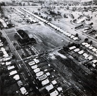
Hooker covered the canal and transferred the property to the Niagara Falls Board of Education in 1953. The 99th Street School opened on the middle portion in 1954, and residential construction accelerated around the former landfill. Complaints of odors, residues, minor explosions, and fumes appeared during the 1960s and intensified after heavy precipitation and the 1977 blizzard helped contaminated liquids reach yards, basements, sewers, and nearby creeks.
Residents—most visibly through the Love Canal Homeowners Association and organizer Lois Gibbs—forced sustained public attention on conditions, health concerns, relocation, and government accountability. State and federal emergency actions in 1978 and 1980 ultimately relocated hundreds of families and helped make Love Canal a catalyst for the federal Superfund law.
Landscape transformation
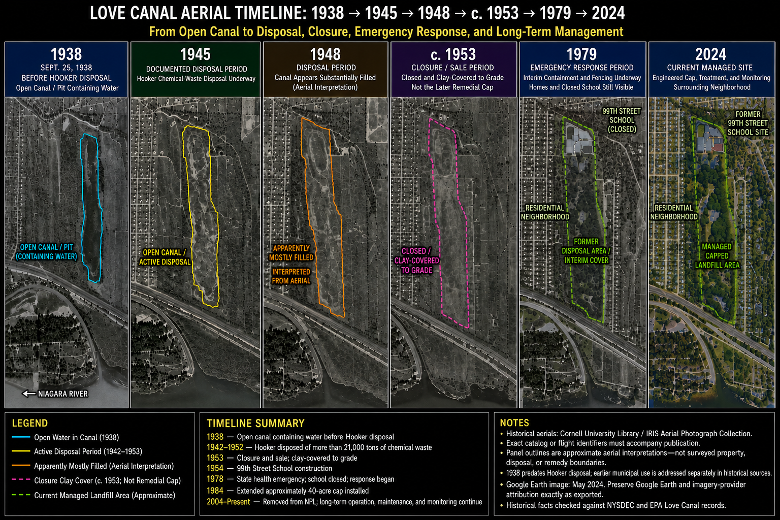
The canal, disposal area, neighborhood, and managed remedy over time
This comparison aligns six aerial views to show visible landscape change. Colored outlines are approximate visual interpretations—not surveyed property, disposal, or remedy boundaries.
Disposal record
Who dumped here, when, and how much?
The records do not support one combined total for everything placed in the canal. The most complete quantity is Hooker's own estimated chemical-waste inventory. Municipal refuse and historically attributed Army disposal are shown separately because their quantities are not established in the reviewed public files.
Documented company disposal
Hooker Electrochemical Company
1942–1953
Hooker, later Hooker Chemical & Plastics and now associated with Occidental Chemical, acknowledged using the canal for wastes from its Niagara Falls plants. EPA records sometimes describe active dumping as ending in 1952; New York records use 1942–1953.
Documented municipal disposal
City of Niagara Falls
During the disposal period; ending in 1953
NYSDEC and NYSDOH records state that the city also used the canal for municipal waste. A 1990 state planning record describes municipal refuse being regularly unloaded into the canal.
Attributed in state records; scope unresolved
United States Army
During and after World War II, historically attributed
A 1990 New York State master-plan appendix says other agencies, including the Army, disposed of toxic chemical waste during and after World War II. Earlier NYSDOH orders directed the Army to continue investigating the extent of its involvement.
Hooker inventory
Estimated chemical wastes, 1942–1953
| Reported waste category | Physical state | Estimated tons | Container |
|---|---|---|---|
| Miscellaneous acid chlorides other than benzoyl | Liquid and solid | 400 | Drums |
| Thionyl chloride and miscellaneous sulfur/chlorine compounds | Liquid and solid | 500 | Drums |
| Miscellaneous chlorination wastes, including waxes, oils, naphthalenes and aniline | Liquid and solid | 1,000 | Drums |
| Dodecyl mercaptans, chlorides and miscellaneous organic sulfur compounds | Liquid and solid | 2,400 | Drums |
| Trichlorophenol (TCP) | Liquid and solid | 200 | Drums |
| Benzoyl chlorides and benzotrichlorides | Liquid and solid | 800 | Drums |
| Metal chlorides | Solid | 400 | Drums |
| Liquid disulfides and chlorotoluenes | Liquid | 700 | Drums |
| Hexachlorocyclohexane (BHC/lindane) | Solid | 6,900 | Drums and nonmetallic containers |
| Chlorobenzenes | Liquid and solid | 2,000 | Drums and nonmetallic containers |
| Benzyl chlorides, including benzyl chloride, benzyl alcohol and benzyl thiocyanate | Solid | 2,400 | Drums |
| Sodium sulfide/sulfhydrates | Solid | 2,000 | Drums |
| Miscellaneous — reported as 10% of the categories above | Not specified | 2,000 | Not specified |
| Total reported by New York State | 21,800 | Drummed and undrummed wastes | |
These are historical estimates reproduced from the 1981 NYSDOH report and its cited 1979 interagency draft. The category figures are rounded, and their displayed arithmetic does not exactly reproduce the published 21,800-ton total. WNYAtlas preserves the official table as reported instead of silently changing a historical source. The list is a disposal estimate—not a complete list of every compound later detected in soil, air, water, sewers, or creek sediment.
News record
Major news events
Coverage selected here marks a turning point in public awareness, policy, enforcement, employment, or cleanup. Links open at the original publisher or archive; WNYAtlas does not reproduce restricted articles or images.
Love Canal becomes a national environmental emergency
Front-page reporting, New York's health-emergency declaration, and President Carter's approval of federal emergency aid transformed a neighborhood contamination story into a national reckoning over hazardous-waste disposal.
U.S. Environmental Protection Agency historical archive ↗Resident organizing and continuing investigations keep the crisis in public view
Local reporting, resident protests, health debates, relocations, and federal action sustained coverage beyond the first emergency announcement and helped shape the emerging Superfund era.
University at Buffalo Love Canal chronology ↗Chronology
Timeline
- 1890s–1930s
William T. Love's power-canal project was excavated and abandoned. A 1938 aerial shows an open, water-filled trench used locally for recreation.
- 1942–1953
Hooker disposed of an estimated 21,800 tons of chemical wastes. New York records also document municipal-waste disposal by the City of Niagara Falls; other wartime disposal was later attributed to the Army, but its scope was not established.
- 1953–1954
Hooker installed a clay cover and transferred the property to the Board of Education. The 99th Street School was built on the middle portion of the former canal.
- 1960s–1977
Neighborhood development surrounded the landfill. Residents reported odors, residues, fumes, and minor explosions; unusually wet conditions culminated in visible migration after the 1977 blizzard.
- 1978
Investigations documented extensive contamination. New York declared a health emergency on August 7, restricted access, recommended relocation for pregnant residents and young children nearest the canal, and began containment and treatment work.
- 1980
President Carter's second federal emergency declaration expanded relocation. FEMA ultimately evacuated about 950 of more than 1,050 families in the Emergency Declaration Area. Congress enacted the federal Superfund law that December.
- 1982–1983
Contaminated homes and the 99th Street School were demolished, and Love Canal entered EPA's first National Priorities List.
- 1985
The state completed the approximately 40-acre cap and improved the collection and treatment system.
- 1988–2000
EPA and New York completed habitability decisions, sewer and creek work, the 93rd Street School cleanup, property management, and off-site treatment or disposal of excavated materials. A court held Occidental liable in 1988; later agreements made the corporate successor responsible for cleanup wastes, site management, and substantial government costs. The last waste shipment left in March 2000.
- 2004
EPA removed Love Canal from the National Priorities List after completion of the required cleanup actions.
- Today
The containment, collection, treatment, inspection, and groundwater-monitoring systems remain under long-term operation and review.
Environmental record
Documented impacts
- Chemical wastes were disposed in the former canal and later enclosed by residential development.
- New York's public-health orders documented pervasive chemical vapors and fumes affecting ambient air and conditions inside some nearby buildings during the emergency period.
- Contaminated liquids, nearby sewers, creek sediment, and portions of the surrounding built environment became part of the cleanup record.
- The site prompted demolition of contaminated houses and the former school within the remedy area.
Response
Cleanup and controls
- A synthetic cap limits rainwater contact with buried material.
- Barrier drains, wells, and the Love Canal Treatment Facility collect and treat contaminated liquids and groundwater.
- The cap, treatment plant, collection systems, and monitoring wells receive continuing inspections, maintenance, and five-year reviews.
Then and now
The site today
EPA reports that construction of the cleanup is complete and that the remedy continues to protect people and the environment. That conclusion depends on the continued operation, maintenance, monitoring, and inspection of the containment systems.
Atlas connections
Connected places
These collections explain documented material, facility, waterway, ownership, or cleanup relationships. Inclusion does not imply that every place shares one contaminant source or plume.
Black Creek Village and Love Canal: historical context
Earlier Area 4 cleanup records provide context. The modern 99th Street findings are not established as a new release from Love Canal.
Hooker Chemical landfill network
Several Niagara Falls disposal sites share a corporate and chemical-manufacturing history while retaining separate boundaries, remedies, and present-day controls.
Love Canal is the best-known Hooker disposal site, but its remedy and neighborhood history are site-specific.
Industrial landfillHooker / Hyde Park LandfillHyde Park is a separately managed landfill with its own migration pathways and remedy.
Niagara River landfillHooker / 102nd Street LandfillThe 102nd Street site connects Hooker disposal history directly to the Niagara River shoreline.
Industrial disposal areaHooker / S-Area LandfillS-Area is another distinct Hooker disposal property governed by its own cleanup record.
Facility-to-river pathwayPettit Flume / Durez OutfallThe Pettit Flume record follows a documented industrial drainage and outfall pathway associated with the Durez operation.
Cayuga Island and the Little Niagara River waste-site landscape
Cayuga Island, Griffon Park, and the 102nd Street landfill occupy one altered river-edge landscape, but government records define separate disposal histories, boundaries, pathways, and investigations.
The island record covers man-made residential extensions, the separate Hennepin Avenue fill case, and the renewed West Rivershore Drive investigation.
Former municipal disposal areaGriffon Park Former Municipal LandfillGriffon Park lies directly across the Little Niagara River and has its own municipal-landfill and groundwater-seep record.
Adjoining industrial landfill complexHooker / 102nd Street LandfillThe Hooker/Olin landfill lies beside Griffon Park along the Niagara River and is governed by a separate federal containment and monitoring remedy.
Nearby but separate disposal siteLove CanalLove Canal provides essential regional history but does not establish the source or extent of fill beneath Cayuga Island.