cleanup · Niagara County
Hooker / 102nd Street Landfill
Niagara Falls
Former industrial landfill where Occidental/Hooker and Olin deposited at least 159,000 tons of liquid and solid chemical waste. The remedy consolidated waste beneath a lined cap, added a slurry wall and recovery systems, and requires long-term groundwater and NAPL monitoring.
The documented story
What happened here?
The 22.1-acre 102nd Street landfill occupies the Niagara River edge: 15.6 acres owned by Occidental Chemical, formerly Hooker, and 6.5 acres owned by Olin. Hooker used its portion from about 1943 to 1971 and Olin used its portion from 1948 to about 1970.
The companies deposited at least 159,000 tons of liquid and solid industrial wastes. EPA records identify mixed solvents, organic and inorganic phosphates, brine and mercury-bearing sludge, fly ash, electrochemical-cell material, and hexachlorocyclohexane process waste among the documented streams.
Because the landfill is beside the Niagara River and partly within its floodplain, the remedy was designed around waste isolation and inward hydraulic control: a synthetic-clay cap, circumferential slurry wall, sediment work, leachate recovery, treatment, fencing, and long-term groundwater and non-aqueous-phase-liquid monitoring.
The river pathway is historical fact, not merely a proximity concern. EPA's remedial investigation identified groundwater discharge from landfill fill and alluvium into the embayment as the principal off-site migration route, and sediment contamination extended to an area within roughly 300 feet of shore. Contemporary reporting in 1993 recorded health officials warning about substances still leaking into the river while the final remedy was being designed.
Later monitoring documents a changed condition. EPA's May 2026 five-year review retained the 2017 conclusion that site-related contamination was not migrating toward the Niagara River, while continuing to find stable residual contamination in several monitoring wells outside the slurry wall. The historical release and the current containment finding belong in the same story, each labeled by date.
Two companies, one riverfront remedy
The quantities tell only part of the story
159,000+tons of industrial waste documented across both owners' areas
1943-about 1971
Adjoining disposal areas received different industrial wastes
Hooker's larger parcel received solvents, phosphates, brine sludge, ash, cell equipment, and lindane-process waste. Olin's adjoining parcel received mixed organic and inorganic chemicals and mercury-bearing brine waste. The sitewide total belongs to both operating histories, not to one company alone.
1982-1995
The river and water-supply pathway drove public concern
EPA's original listing narrative identified leaching toward the Niagara River upstream of the city's intake tunnels as a major concern. Investigation and remedy design focused on isolating the waste and stopping outward groundwater movement rather than claiming that every downstream person had been exposed.
1996-present
A wall, cap, and pumps replaced an open industrial edge
Crews installed a circumferential slurry wall, removed affected embayment sediment, built a permanent cap, and sent recovered liquid to treatment. EPA removed the site from the national list in 2004, but access controls, pumping, monitoring, and five-year reviews continue.
Historical aerial evidence · fourth release
Two adjoining dumps changed one Niagara River shoreline
The earliest verified public frame covering the 102nd Street Landfill and neighboring Griffon Park is a June 1958 USGS photograph. DEC records describe Griffon as a separate city-owned disposal area: wetland before 1938, municipal refuse fill from 1949 to about 1953, and intermittent tree burning and disposal of municipal-incinerator residue and other noncombustibles into the early 1970s. Immediately east, Hooker and Olin operated the separately owned 22.1-acre industrial landfill into 1970-1971. Four later New York State orthophotos use one fixed geographic window to show both river-edge landscapes during remedy construction, after construction completion, and under long-term management.
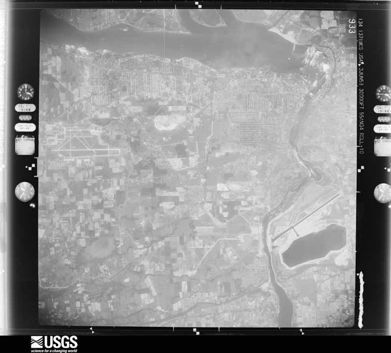
USGS acquired this 1:60,000-scale frame on June 3, 1958. DEC says routine city refuse disposal at Griffon had ended about five years earlier, although intermittent burning and incinerator-residue disposal continued; the adjoining Hooker and Olin areas were both operating. The altered shoreline can appear continuous at this scale, but the photograph does not establish that these separately recorded disposal areas were one pit or shared the same wastes.
USGS frame ARA550340100933 ↗Choose a year. On touch screens, swipe the image to move through time.
News record
Major news events
Coverage selected here marks a turning point in public awareness, policy, enforcement, employment, or cleanup. Links open at the original publisher or archive; WNYAtlas does not reproduce restricted articles or images.
State officials warn that 102nd Street chemicals are leaking into the Niagara River
The archived report records the pre-remedy river pathway while agencies and the responsible companies were still developing the containment system. It is historical evidence, not a description of post-construction conditions.
The Buffalo News archive ↗EPA's sixth review finds the remedy protective while identifying monitoring watch items
EPA retained the conclusion that site-related contamination was not migrating toward the river, documented continuing leachate and NAPL recovery, and suggested follow-up for one hydraulic well pair and 1,4-dioxane monitoring.
U.S. Environmental Protection Agency ↗Chemical guide
Chemicals named in this record
These links explain potential hazards and exposure pathways. A chemical named in a record does not establish that anyone was exposed or harmed.
Chronology
Timeline
- 1943-1971
Hooker and Olin operated adjoining disposal areas for bulk liquid and solid chemical wastes.
- December 1970
The U.S. Army Corps of Engineers inspected the property, cited disposal practices under the Rivers and Harbors Act, and the companies stopped further landfilling.
- 1972
The property was capped, fenced on three sides, and given a riverfront bulkhead as an early control.
- 1983
EPA placed the site on the National Priorities List after investigation of soil, groundwater, and riverward pathways.
- 1990-1995
EPA selected and then amended the final containment remedy, including the cap, slurry wall, sediment handling, and liquid recovery.
- August 1993
Contemporary Buffalo News reporting preserved state health officials' warning that cancer-linked substances were still leaking from the landfill into the Niagara River before construction of the modern containment system.
- 1996-1999
Crews built the slurry wall, removed affected embayment sediment, installed the permanent cap, and connected leachate pumping to the Love Canal Treatment Facility.
- 2004-present
EPA deleted the site from the NPL after remedy construction; pumping, monitoring, maintenance, access limits, and periodic review continue.
- 2017-2026
Surface-water and sediment testing found no site-related contaminants in sampled surface water and sediment results below the cited Class A guidance values; EPA's 2026 review continued to regard that river-migration conclusion as valid.
Environmental record
Documented impacts
- Large volumes of mixed chemical waste remain within the landfill.
- Contaminated groundwater and NAPL created potential pathways toward the Niagara River.
- Several VOCs, SVOCs, and pesticides remained above state groundwater criteria in four perimeter overburden wells during 2020-2025; EPA interpreted the stable detections as residual contamination outside the wall rather than evidence of a new wall breach.
- State-led 2019 emerging-contaminant sampling found 1,4-dioxane above New York's later drinking-water value in several sampled wells. EPA's 2026 review suggested adding it to the groundwater monitoring program. PFAS detections were not interpreted as a significant site source.
- Waste ownership and source history involve two adjoining industrial operators; a sitewide total should not be assigned to one company alone.
Response
Cleanup and controls
- A lined cap limits exposure and infiltration over consolidated waste.
- A subsurface slurry wall and liquid-recovery systems contain migration.
- Groundwater, NAPL, treatment systems, and institutional controls receive long-term monitoring.
- Monitoring includes quarterly hydraulic measurements at ten paired locations, quarterly checks at eight NAPL recovery wells, and annual VOC, SVOC, and pesticide sampling from ten overburden and three bedrock wells.
- From 2020 through 2025, the system recovered 520,812 gallons of aqueous-phase leachate for treatment. From 2021 through 2025, operators recovered 2,834.8 gallons of NAPL for off-site management.
Then and now
The site today
The landfill remains a contained-waste remedy beside the Niagara River. EPA's May 2026 review found the remedy protective and the cap in excellent condition. It noted no formal issues, but suggested evaluating one well pair if outward-gradient events continue and adding 1,4-dioxane to routine groundwater monitoring.
EPA deletion in 2004 recorded a completed remedy, not unrestricted soil or removal of the waste mass; protectiveness depends on the cap, wall, recovery, testing, and institutional controls continuing to work.
Atlas connections
Connected places
These collections explain documented material, facility, waterway, ownership, or cleanup relationships. Inclusion does not imply that every place shares one contaminant source or plume.
Wartime chemical production and its environmental record
WWI agent production, a mustard-gas plant project, WWII protective treatment and later disposal histories have different evidence. These connections do not establish continuous warfare-agent manufacture, a shared plume, or a verified destination for WWI gas-production wastes.
DEC identifies Area D phosgene manufacture; military records document a mustard-gas project with unresolved actual output.
Oldbury predecessor productionHooker Main Plant / Occidental Niagara PlantOldbury manufactured phosgene in 1918, decades before its acquisition by Hooker.
WWII and Korean War protective treatmentSolvent Chemical SiteDuPont and later Hooker manufactured impregnite at 3163 Buffalo Avenue. The treatment was protective, not proof of poison-gas production.
Later Oldbury disposal connectionHooker / 102nd Street LandfillOldbury acquired landfill parcels in 1924. Later phosphorus-waste burial does not establish a destination for its 1918 gas-production wastes.
Hooker Chemical landfill network
Several Niagara Falls disposal sites share a corporate and chemical-manufacturing history while retaining separate boundaries, remedies, and present-day controls.
Love Canal is the best-known Hooker disposal site, but its remedy and neighborhood history are site-specific.
Industrial landfillHooker / Hyde Park LandfillHyde Park is a separately managed landfill with its own migration pathways and remedy.
Niagara River landfillHooker / 102nd Street LandfillThe 102nd Street site connects Hooker disposal history directly to the Niagara River shoreline.
Industrial disposal areaHooker / S-Area LandfillS-Area is another distinct Hooker disposal property governed by its own cleanup record.
Facility-to-river pathwayPettit Flume / Durez OutfallThe Pettit Flume record follows a documented industrial drainage and outfall pathway associated with the Durez operation.
Cayuga Island and the Little Niagara River waste-site landscape
Cayuga Island, Griffon Park, and the 102nd Street landfill occupy one altered river-edge landscape, but government records define separate disposal histories, boundaries, pathways, and investigations.
The island record covers man-made residential extensions, the separate Hennepin Avenue fill case, and the renewed West Rivershore Drive investigation.
Former municipal disposal areaGriffon Park Former Municipal LandfillGriffon Park lies directly across the Little Niagara River and has its own municipal-landfill and groundwater-seep record.
Adjoining industrial landfill complexHooker / 102nd Street LandfillThe Hooker/Olin landfill lies beside Griffon Park along the Niagara River and is governed by a separate federal containment and monitoring remedy.
Nearby but separate disposal siteLove CanalLove Canal provides essential regional history but does not establish the source or extent of fill beneath Cayuga Island.