cleanup · Niagara County
Hooker / S-Area Landfill
Niagara Falls
Eight-acre former chemical-waste landfill beside the Niagara Falls drinking-water treatment plant. The remedy includes a final landfill cap, source containment, groundwater collection and treatment, and continuing monitoring.
The documented story
What happened here?
S-Area is an approximately eight-acre former Hooker Chemical landfill between Buffalo Avenue and the Niagara River, immediately beside the Niagara Falls drinking-water treatment plant. Hooker disposed of about 63,000 tons of chemical-processing wastes there, making the physical relationship to the water plant central to every investigation and remedy decision.
Federal studies documented affected soil, sediment, overburden and bedrock groundwater, including aqueous and non-aqueous chemical phases that moved toward water-plant structures. That historical finding concerns subsurface migration near the facility; it is not by itself evidence that present finished drinking water is contaminated.
The remedy left the waste in place beneath an engineered cap and combined hydraulic containment, collection and treatment with modifications or abandonment of affected subsurface plant structures. Long-term monitoring tests whether the systems continue to separate the landfill from critical water infrastructure.
A landfill beside essential infrastructure
The water plant made containment a public necessity
63,000tons of chemical-processing waste estimated by EPA
1947-1961
Chemical disposal grew beside a municipal water facility
Hooker disposed of organic and inorganic chemical wastes at S-Area while the neighboring water plant continued serving Niagara Falls. The land-use conflict was not hypothetical: the landfill and plant shared a narrow riverfront setting above fractured bedrock.
1969-1983
Routine inspection led to a larger investigation
A 1969 water-plant inspection found small amounts of chemicals in intake structures. Later sampling found contamination in an intake tunnel and plant-property soil. The Water Authority closed the affected bedrock intake structures in 1983 as the Superfund investigation proceeded.
1990-present
The remedy protects infrastructure as well as land
The selected work capped and contained the landfill, collected contaminated groundwater, treated recovered liquids, and modified or abandoned affected plant structures. Continued sampling and five-year reviews are part of the protection—not an optional epilogue.
Historical aerial evidence · fifth release
Before disposal, during operation, and under long-term containment
EPA's historical-photo analysis supplies two unusually strong views of S-Area: a September 25, 1938 vertical photograph showing the earlier shoreline and future site boundary, and an annotated August 9, 1958 oblique view acquired while chemical-waste disposal was documented. Three later New York State orthophotos use one fixed geographic window to show the property during remedy construction, shortly after completion, and under current long-term management.
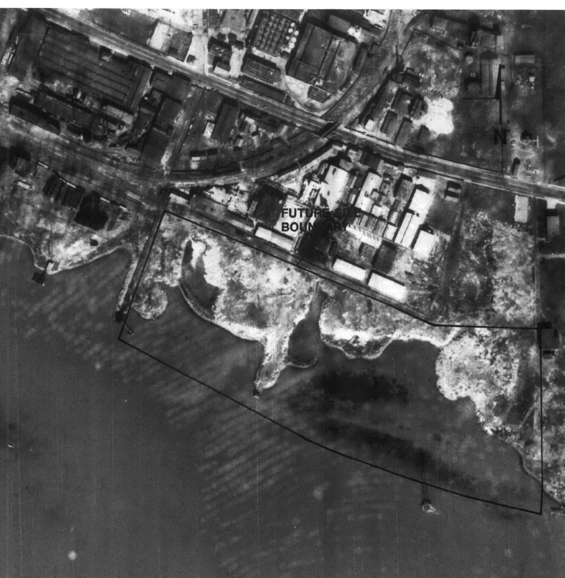
EPA dated this vertical aerial September 25, 1938 and printed it at an approximate scale of 1:3,100. The bright yellow trace follows the agency's overlaid future S-Area boundary. Because EPA records place chemical-processing-waste disposal beginning in 1947, this photograph provides a pre-disposal baseline for the shoreline and industrial landscape.
EPA Figure 2-6 ↗Choose a year. On touch screens, swipe the image to move through time.
Chronology
Timeline
- Industrial disposal era
Hooker Chemical placed roughly 63,000 tons of chemical-processing waste in the landfill.
- 1979
The United States sued Hooker over S-Area and three other Niagara Falls dumps, citing the risk posed by chemicals near the drinking-water plant.
- 1983
EPA placed S-Area on the National Priorities List and began the formal Superfund investigation.
- 1990
EPA selected the final remedy for the landfill, groundwater plume, bedrock contamination, and affected water-plant structures.
- 1990-2002
Containment, cap, collection, treatment, and infrastructure work moved through design and construction.
- 2002-present
Construction was completed; operation, maintenance, sampling, and five-year reviews continue, and the site remains on the NPL.
Environmental record
Documented impacts
- Mixed chemical wastes remain buried within the landfill.
- Groundwater contamination required active collection and treatment.
- Historic migration toward bedrock intake structures increased the consequence of remedy failure, though proximity and historic subsurface impacts do not establish a current finished-water exposure.
Response
Cleanup and controls
- The final landfill cap prevents direct contact and limits rainwater infiltration.
- Containment and groundwater collection intercept migration for treatment.
- Long-term sampling, inspections, maintenance, and land-use controls preserve protectiveness.
Then and now
The site today
S-Area is a controlled, operating containment remedy and had not been deleted from the NPL as of the 2024 federal review. The atlas distinguishes documented landfill and groundwater impacts from the treated municipal water supplied by the neighboring plant.
Atlas connections
Connected places
These collections explain documented material, facility, waterway, ownership, or cleanup relationships. Inclusion does not imply that every place shares one contaminant source or plume.
Hooker Chemical landfill network
Several Niagara Falls disposal sites share a corporate and chemical-manufacturing history while retaining separate boundaries, remedies, and present-day controls.
Love Canal is the best-known Hooker disposal site, but its remedy and neighborhood history are site-specific.
Industrial landfillHooker / Hyde Park LandfillHyde Park is a separately managed landfill with its own migration pathways and remedy.
Niagara River landfillHooker / 102nd Street LandfillThe 102nd Street site connects Hooker disposal history directly to the Niagara River shoreline.
Industrial disposal areaHooker / S-Area LandfillS-Area is another distinct Hooker disposal property governed by its own cleanup record.
Facility-to-river pathwayPettit Flume / Durez OutfallThe Pettit Flume record follows a documented industrial drainage and outfall pathway associated with the Durez operation.