waterway · Erie County
Buffalo River
Buffalo
Industrial corridor where an oil-fed 1968 river fire became a stark symbol of severe pollution, followed decades later by contaminated-sediment cleanup, habitat restoration, and long-term recovery work.
The documented story
What happened here?
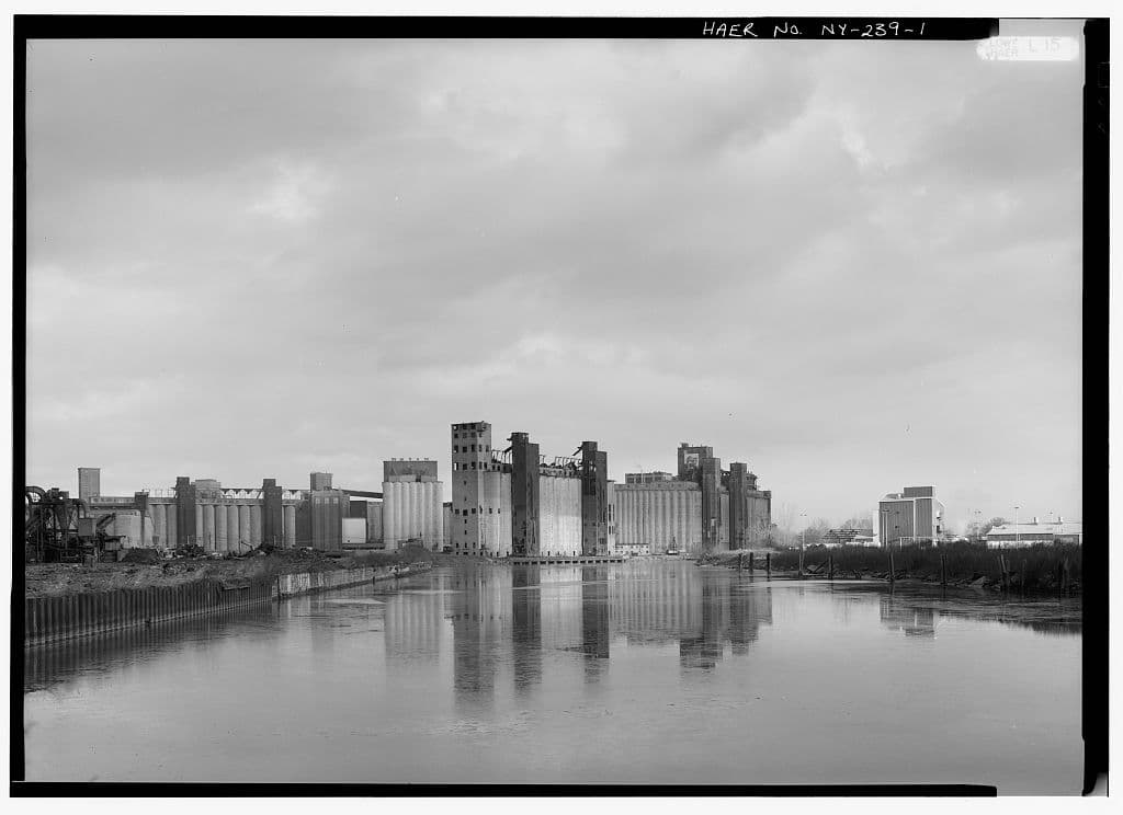
The Buffalo River became the western terminus of the Erie Canal in 1825. Grain elevators, steel mills, meatpacking, chemical works, petroleum facilities, municipal systems, and other industries concentrated along its banks, using the river as transportation infrastructure and, historically, as a receiving water.
On January 24, 1968, oil and other combustible pollution on the river ignited. EPA records say the fire continued for nearly three days. The event did not create the river's pollution crisis; it made an already severe industrial and municipal waste problem dramatically visible.
By 1987, the United States and Canada had designated the Buffalo River as a Great Lakes Area of Concern because contamination and habitat loss impaired environmental and recreational uses. Its modern story is one of sediment remediation, navigation dredging, shoreline restoration, monitoring, and the gradual removal of formally identified beneficial-use impairments.
January 24, 1968
When the Buffalo River burned
EPA records say a fire ignited on the Buffalo River on January 24, 1968. It was the oil and other combustible pollution on the water that burned—not the water itself. An EPA review of the river's recovery says the fire continued for nearly three days.
Conditions before the fire
Industrial and municipal discharges had overwhelmed the river by the 1950s and 1960s. A 1968 federal assessment described an oxygen-depleted, almost sterile river receiving oil, phenols, and other wastes in large amounts.
What the fire established
The event made extreme surface pollution impossible to ignore. It remains a stark local marker of the river's industrial condition, but the fire alone does not describe the full sediment, habitat, sewer, or shoreline contamination record.
What followed
The fire occurred amid years of local advocacy and expanding state and federal pollution controls. Later Area of Concern work addressed contaminated sediment, degraded habitat, aesthetics, and other documented impairments through cleanup, restoration, and monitoring.
News record
Major news events
Coverage selected here marks a turning point in public awareness, policy, enforcement, employment, or cleanup. Links open at the original publisher or archive; WNYAtlas does not reproduce restricted articles or images.
The Buffalo River burns for nearly three days
Oil and combustible pollution ignited on a river already severely damaged by industrial and municipal waste. The fire became the enduring public image of the river's environmental crisis.
U.S. Environmental Protection Agency ↗Large-scale contaminated-sediment cleanup changes the river's trajectory
Federal, state, industrial, and community partners completed major dredging, capping, and habitat work, reframing coverage from industrial decline toward environmental recovery.
U.S. Environmental Protection Agency ↗Chronology
Timeline
- 1825
The opening of the Erie Canal helped establish the Buffalo River as a major industrial and transportation corridor.
- January 24, 1968
Oil and combustible pollution on the Buffalo River caught fire. EPA's later recovery record says the fire burned for nearly three days.
- 1987
The river was designated a Great Lakes Area of Concern under the binational Great Lakes Water Quality Agreement.
- 2013–2015
EPA and Honeywell completed major dredging and capping work on contaminated sediment outside and below the navigation channel.
- 2020–2021
Strategic navigation dredging and final cleanup work addressed remaining targeted sediment areas.
- Present
Monitoring and habitat work continue as agencies evaluate the remaining beneficial-use impairments required for eventual delisting.
Environmental record
Documented impacts
- Historic industrial and municipal activity introduced pollutants to the river and contributed to contaminated sediment.
- By the 1950s and 1960s, federal accounts described an oxygen-depleted, nearly sterile river receiving oil, phenols, and other wastes; combustible surface pollution fed the documented 1968 fire.
- The Area of Concern record identified restrictions involving dredging, fish and wildlife, degraded benthic communities, habitat loss, aesthetics, and other uses.
- Contamination and physical alteration of the shoreline affected ecological function as well as navigation and recreation.
Response
Cleanup and controls
- Nearly 500,000 cubic yards of contaminated sediment outside and below the navigation channel were remediated through dredging and capping.
- Additional navigation dredging targeted residual contamination in five channel areas.
- Multiple projects restored in-water, riparian, wetland, and upland habitat along former industrial shorelines.
Then and now
The site today
EPA reports substantial environmental recovery and the removal of multiple beneficial-use impairments. The river remains an Area of Concern until all required impairment-removal criteria are met and the formal delisting process is completed.
Atlas connections
Connected places
These collections explain documented material, facility, waterway, ownership, or cleanup relationships. Inclusion does not imply that every place shares one contaminant source or plume.
Buffalo Color facility and river system
Plant parcels, sewer pathways, shoreline areas, and Buffalo River sediment records overlap geographically but are governed through different cleanup programs.
The main record covers the former dye and organic-chemical plant and its parcel-specific cleanup history.
Plant-area recordBuffalo Color Area E / Former Medaille FieldArea E is tracked separately so conditions on one portion of the former complex are not generalized to every parcel.
Receiving water and sediment remedyBuffalo RiverThe river record provides the larger sediment-remediation and habitat-restoration context for shoreline industries.
Buffalo River industrial corridor
Industrial parcels, former disposal areas, sediment remedies, and restored habitats form a shared river corridor while retaining separate ownership and cleanup records.
The river is the organizing environmental system for this collection.
Chemical-manufacturing shorelineBuffalo ColorBuffalo Color represents a major industrial parcel with documented sewer and shoreline pathways.
Steel and coke landscapeRepublic SteelThe former Republic Steel landscape links heavy industry, managed brownfields, and riverfront redevelopment.
Former industrial propertyIroquois Gas / Westwood PharmaceuticalThis property adds a distinct industrial and cleanup history within the broader river corridor.
Peninsula cleanup areaKatherine Street PeninsulaThe peninsula record connects upland contamination, shoreline conditions, and river restoration.
Landfill and steel propertyAlltift Landfill / Ramco SteelAlltift links filled industrial land to the river corridor's disposal history.
Recovered landscapeTifft Nature PreserveTifft shows the corridor's transition from industrial and filled land to habitat and public use.
Confined-disposal and habitat siteTimes Beach Confined Disposal SiteTimes Beach connects dredged-material management with later habitat value.